


Sound Transit has settled a claim made by Beacon Hill homeowners over damage to the property caused by voids that formed after light rail tunneling some 135 feet below. But, don’t fear, representatives for the transit agency say that special tunneling machines will prevent the same problems from happening on Capitol Hill when twin tunnels are bored between downtown and the University of Washington. More on that machine — and the route the tunnels will take below Capitol Hill, well, below.
According to KING 5, Sound Transit has agreed to buy the Beacon Hill home and compensate for the situation by paying the couple $476,000.
UPDATE 1:55 PM: Here is Sound Transit spokesperson Bruce Gray’s response to us about how the Capitol Hill tunneling work will better handle sandy voids:
We have different contractors doing the tunneling and using lessons learned from Beacon Hill, we’ll have a more exhaustive monitoring program of all tunneling activities. In a nutshell, the contractor took out too much material while boring a small section of the Beacon Hill tunnels.
During tunneling you can estimate how much material you need to excavate per foot or so. If you see more material coming out, it tells you there may be something flowing into the path of the TBM from above – sand, water, loose soils – and you make adjustments to keep those materials out. At its most basic level, you make adjustments to the pressure your machine is exerting from its face and sides. This pressure can come from a clay-like mixture being pushed out of the sides or face of the machine.
One new measure we’ll be using to monitor the ground and excavation conditions during U-Link tunneling will be constant measurements of the ambient earth pressure on the head of the TBM. Being able to see this in real time will give us a better picture of how much pressure should be on the cutter head as it’s excavating. Maintaining the proper “earth pressure balance” ensures you are removing the appropriate volume of materials. Essentially, you want maintain enough pressure on the head of the machine to keep materials from the sides of your tunnel from being excavated. Knowing the ambient pressure will tell us if the contractor is maintaining the proper pressure from the TBM side.
Sound Transit has said that the voids discovered Beacon Hill are the result of the displacement of pockets of sandy soil by the tunnel boring process. The voids have small openings and expand as you go deeper until rounding out in a base like a tea kettle. The discovery of seven such major voids around Beacon Hill tunneling in 2009 prompted a review of the process used to bore the tunnels and a change of plans for the process on Capitol Hill.
Sound Transit documents detailing the geology and soils of the planned University Link tunnels say the same type of structures exist deep underneath Capitol Hill.
Glacial lacustrine deposits were encountered beneath the outwash deposits to the depth of the borings (130 to 160 feet). For alternatives to Capitol Hill, greater thicknesses of pre-Vashon non-glacial fluvial deposits were observed in borings drilled by the PSTC Design Team (2005), which appear to thicken from upwards of 60 to 80 feet of granular soils near the Montlake Cut to more than 130 feet near E Roy Street.
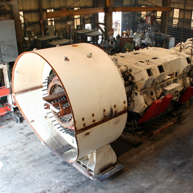 The TBM (Photo: Frontier-Kemper)
Sound Transit dug dozens of test bores across the Hill, some down to about 400 feet near the water tower at Volunteer Park. The results confirmed the comparable geology — layers of clay and sand throughout most of the Hill.
According to Sound Transit, the company that won the contract to bore the tunnel from UW to Capitol Hill will use a machine capable of better handling these kinds of conditions.
The Traylor/Frontier-Kemper tunnel boring machine is reportedly capable of exerting high pressure as it digs thus holding loose soil in place as the tunnel rings are put in place. The machines also inject grout as they dig to further stabilize the soil.
That doesn’t mean some residents and property owners near the path of the planned twin light rail tunnels aren’t concerned. Broadway Investment, Ltd, owners of the apartment building that also houses American Apparel across the street from the light rail station construction area in August voiced their concerns about possible damage to their 1924 building. Sound Transit is quick to point out that the landowner has already agreed on a +$200,000 easement agreement with the agency, one of nearly 200 such agreements the agency has worked on along this line of light rail.

Cross-segment from TunnelTalk.com: U-Link-mobilization
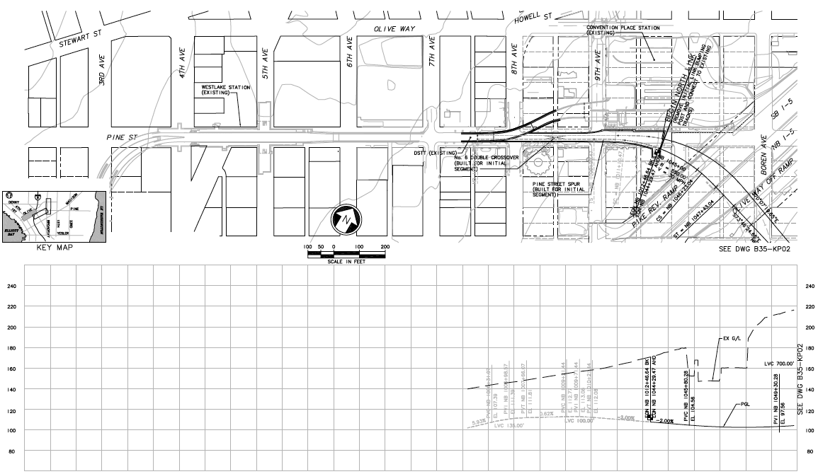
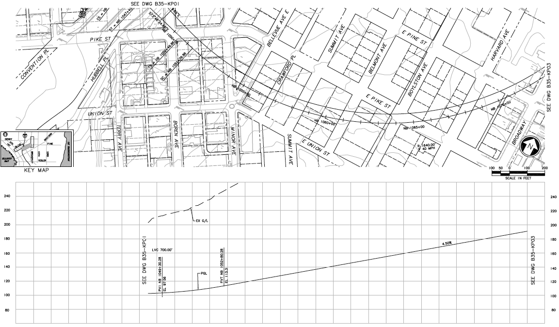
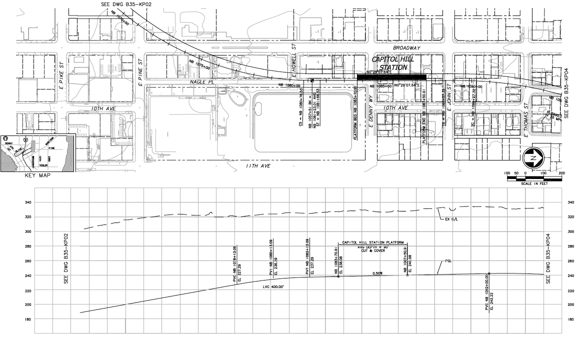
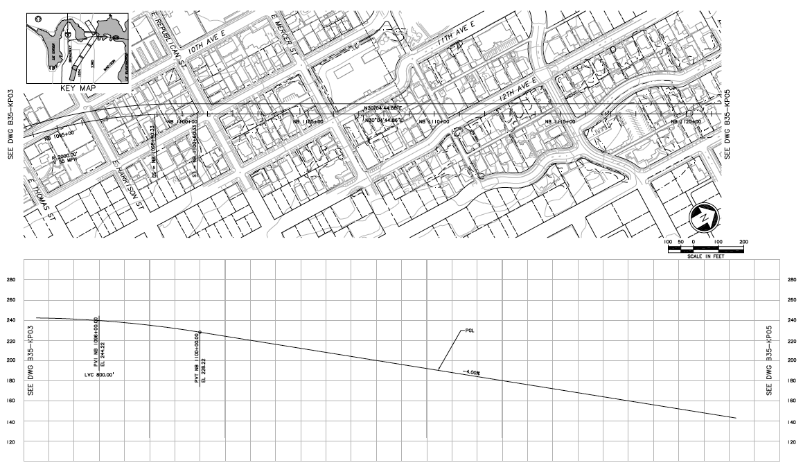
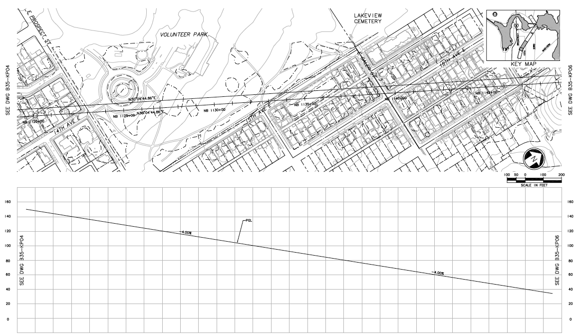
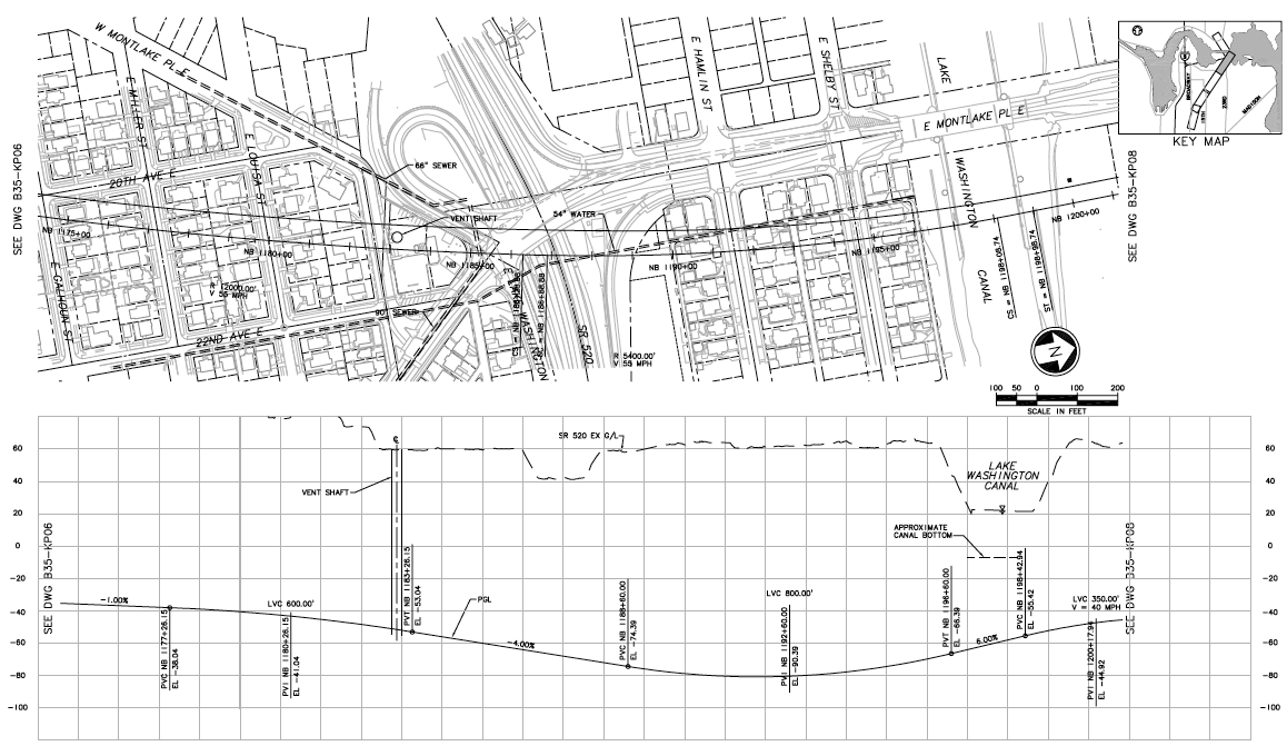
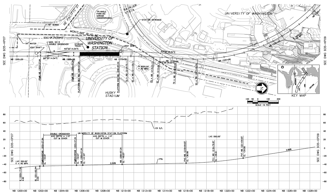
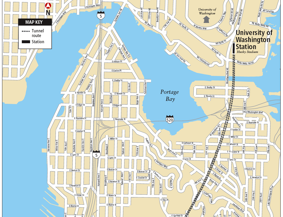
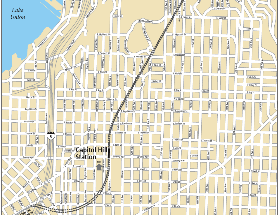
Below, we’ve included detailed maps from Sound Transit’s early alignment documentation that was submitted as part of the final environmental impact statement required for this scale of project. We’re checking with Sound Transit to see if any plans for alignment have changed since this was submitted. You can see both the planned alignment and the elevation of the tunneling in the lower section of each graphic. Keep in mind the elevation scale changes as the tunnel segments illustrated shift from areas where the boring will be around 100 feet below ground between Pine and Broadway and more than 300 feet deep in some areas on the way downhill to Montlake.
The maps run in order from Pine to Montlake.
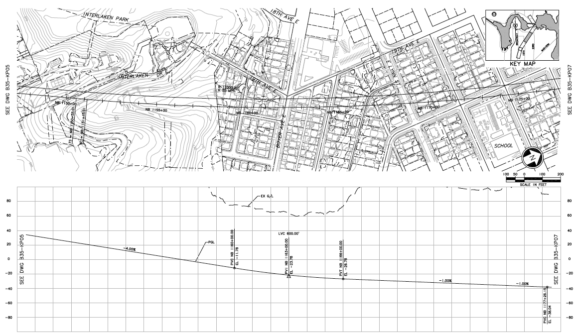
If the tunnelling machine hasn’t been fixed the way they think, the Volunteer Park Cafe could be swallowed up in a sinkhole as the tunnel is dug directly underneath it.
Which would certainly be one way to resolve their zoning/permitting problem.
Here’s a link to plans that are more up-to-date than the plans shown above. The materials were presented at an Open House held September 6, 2007 for the property owners affected by acquisition of tunnel easements for the University Link light rail project. Easement settlements made w/property owners were based on these maps.
Any chance that a Volunteer Park station could be built in the future if the money were available. This is an awfully large area for just one station. I know that First hill (Madison and Broadway) was supposed to get a station and that would have helped, but Cap hill is so big for just one station. Thats probably my biggest disappointment with this line. Otherwise I Can’t wait for it to open.
Agreed: As a former New Yorker, I’ve seen some serious tunnelling plans, and often there’s a better sense of longterm civic & planning needs.
I’m sorely pertrubed that this tunnel route doesn’t swing east, over to the denser and commerce-zoned 15th or 19th, before heading down to montlake. At least IN ANTICIPATION that SOMEDAY the city might want a station over there. Or might want to intersect with another mode (say, like a streetcar line on 23rd or 19th).
(the parking lot at 17th and Thomas would be a great station location, for example… also near Group Health, Miller Playfield, etc etc)
The current route doesn’t make long-term planning sense in the least… unless we’re building a light rail that’s only for our lifetimes, and not SEVERAL lifetimes…
ST big-picture vision = Fail
You have just described Seattle to a T. Seattle has zero sense of long term planning–they never plan for more than about a year ahead. They have no idea how to see the big picture. And this has been the case for the entire time it has been settled. That is really Seattle’s one biggest negative–lack of planning for the future.
It’s true Seattle is always planning for the way things are right now. Sometimes it feels like the city is trying to perpetuate how it has been in the last 10 or 20 years instead of thinking about what could be.
My peeve with ST is that they don’t make the connections. The airport station is not in the airport. The bus lines at the McClellan station all stop across Rainier from the station instead of at the station. At Westlake the busses, tunnel, streetcar and monorail all do not connect. Thge Cap hill streetcar will not connect with the defunct waterfront streetcar even though the tracks both end at 5th and Jackson. The commuter rail at King st. does not connect to other transit. Connections in Seattle get close but there always seems to be 1-2 blocks in the rain to make a connection.