


With a blustery storm already blowing in, the National Weather Service has issued a ‘special weather statement’ for western Washington that includes — WA Niña style — “a risk of snow.”
COLD AIR IS EXPECTED TO DEVELOP OVER WESTERN CANADA DURING THE UPCOMING WEEK. THERE ARE STRONG INDICATIONS THAT CHANGES IN THE WIND FLOW ALOFT TOWARD THE END OF THE WEEK WILL ALLOW SOME OF THIS COLDER AIR OVER WESTERN CANADA TO FILTER INTO WESTERN WASHINGTON FRIDAY OR SATURDAY.
WEATHER GUIDANCE ALSO SUGGESTS THAT THERE IS A RISK OF SNOW…OR MIXED RAIN AND SNOW SHOWERS OVER PORTIONS OF THE AREA FRIDAY OR SATURDAY. THE HIGHEST RISK WILL BE WHERE THE AIR IS COLDER…OVER THE NORTH INTERIOR.
WHILE WEATHER GUIDANCE HAS BEEN CONSISTENT IN SHOWING A CHANGE TO A COLDER WEATHER PATTERN…THEY HAVE BEEN UNEVEN IN SHOWING HOW COLD IT WILL GET AND HOW MUCH…IF ANY…SNOW WILL FALL.
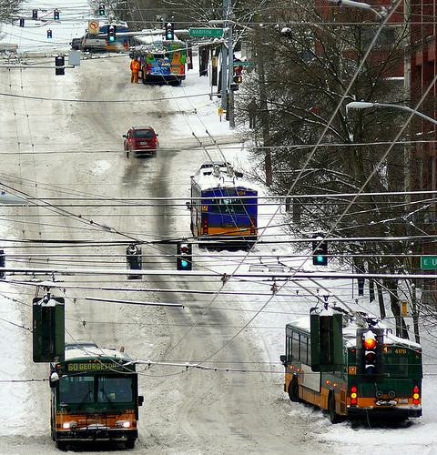
While this first foray into flurries doesn’t sound like it will be significant, in past snow days on the Hill, the biggest problems have been the roadways, of course. Metro buses getting stuck and/or taking impossible to track alternate routes. Un-plowed streets.
We’ve already posted about Metro’s plans for what is expected to be a colder and possibly more snowy winter than usual around Seattle. Here’s the summary of online tools to help you catch your bus:
• Sign up to receive Transit Alerts for the routes you use most often;
(www.kingcounty.gov/metro/signup)• Check the print and online timetables for snow route maps;
(www.kingcounty.gov/metro)• If the weather is bad, check the color-coded status map on Metro Online before you travel;
(www.kingcounty.gov/metro/snow)
Also, there’s a new Metro alert Twitter account that the agency says isn’t ‘officially’ ready for use yet — we’ve been following and getting bombarded by tweet occasionally: http://twitter.com/kcmetroalerts
SDOT is also facing winter 2010/2011 with a fresh plan including a tiered plan to clear Seattle streets of snow. In SDOT’s maps, you can check out your area of the Hill to see what will be plowed and what won’t. SDOT has broken up the Hill across three different snow service areas, by the way — Downtown, Central-South, and Northeast (PDFs). We don’t know how that will impact service but it’s something to watch if things play out the way the weather folks are predicting. SDOT snow service tiers are below.
o Service Level 1 ORANGE – bare and wet from curb to curb
o Service Level 2 BLUE – bare and wet in one lane in each direction
o Service Level 3 GREEN – deicing treatment on curves, hills and stopping zones.
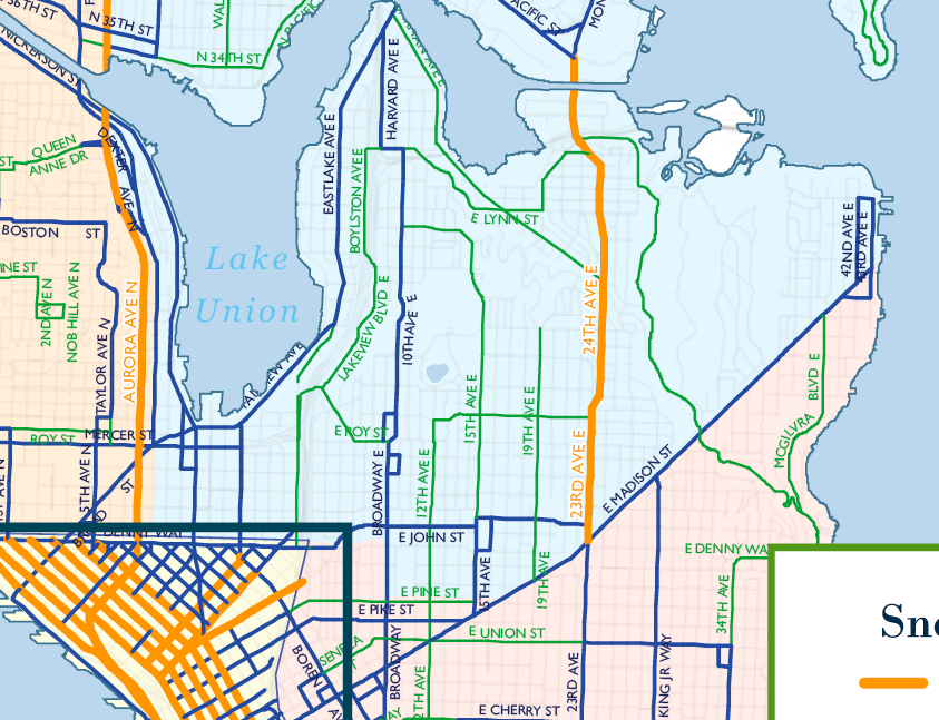
SDOT explanation for route selection:
Routes were selected using criteria that include the busiest streets that connect our neighborhoods with downtown or within the greater Puget Sound region; streets used by the transit agencies even in harsh weather; streets used most frequently by public safety agencies; and streets deemed important to public institutions such as schools, universities and hospitals, and also Seattle’s major employers.
As for how the plan plays out on Capitol Hill, we might be with University of Washington meteorologist Cliff Mass who says SDOT should focus its snow removal on fewer, more critical streets:
Now the city has 30 plows. Lets say that 25 are available at any one time (which would be very good I would think). And lets assume that they plow at 20 mph. So they could cover at best roughly 500 miles of roadway an hour. How many miles of roadway lanes are included in the routes outlined in the map…my rough estimate is 1200 lane miles. So it would take 2.5 hours to cover the city–and that is optimistic. If the snowfall is relatively light (.5-1 inch an hour) this might be ok, but if the snow is heavy (several inches per hour) there is going to be trouble. My suggestion: have a smaller core set of major streets that get priority in heavy snow. Get those clear, keep them clear, and steer the buses to those streets.
While we’re not sure we’d trade a green 15th Ave East so that Broadway could go orange, there are a few streets in neighborhoods outside the city’s core we’d gladly throw into the green zone in exchange for an orange Madison.
Addendum to Cliff Mass’s post from Saturday:
NOTE: I will be posting about snow and cold tonight…bottom line: no or very little snow in the lowlands. Media hype has begun, so beware!
wait a second. Pretty sure Cliff counts as ‘media’ now. Pot. Kettle. Black.
http://cliffmass.blogspot.com/2010/11/is-it-going-to-snow-ov
Anyway, we are now close enough to the weekend, and the models are in good enough agreement, and I am comfortable talking about what I see happening.
Bottom line: forget lowland snow but lots of snow in the mountains.
but it *is* very windy. gusts over 40 mph in the city. No reports of power out around the Hill. Isolated outages across Seattle.
As a car-free person who lives on the hill, I say, “Let it snow!”
Seconded!
Hell yes! If only my fancy new apartments had windows & doors that actually sealed! :(