


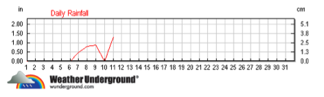
With heavy rain forecast to continue into Sunday night from a powerful pineapple express storm, city officials say more than 3 inches fell on Seattle in a 24 hour period pushing gutters to overflow, soaking the ground and increasing the chance for landslides to dangerous levels. Our local source of weather data — a weather station in Volunteer Park — reports just over 2.2 inches of rain in the past 24 hours. You can see graphs of the day and the monthly trend below.
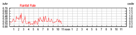
You can see that since around 6 AM, we’ve been getting around 1/4 inch of rain per hour according to the Volunteer Park rain gauge.
Seattle Public Utilities reports that the city is now over the “landslide threshold” increasing the risk of hillside slippage. One report has a hillside along Lake Washington Blvd South causing a blockage on the roadway. Dangerous slides around Capitol Hill are relatively rare but this January 1997 incident in which a townhouse slid a few feet on the side of the Hill above I-5 caused thousands of dollars of damage and lead to legal actions against the city.
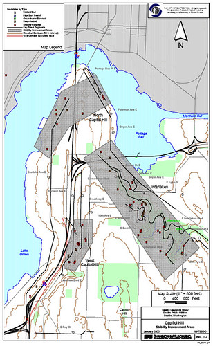
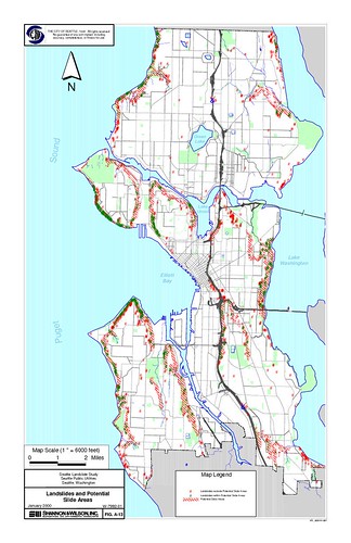
Here is a map showing landslides in our area of the city by decade.

A more common risk is rain-heavy trees toppling in the wet soil. So far, no reports of that.
According to a City of Seattle report, the areas of the Hill most at risk for landslide slippage are relatively obvious — west above I-5, north above Eastlake and Montlake and the Interlaken area. Of those three, Interlaken has seen by far the most historical activity, mostly involving shallow, relatively minor slips. The report says Interlaken’s subsurface conditions differ from the other two areas in that its layers of underground clay are more pure and don’t include a sandy mix like you would find if you dug deep under I-5 Shores. The biggest threat for slides historically comes in January as rainfall accumulations build during rainy Novembers and Decembers.
Meanwhile, our area has not suffered any widespread power outages though other parts of the city including West Seattle haven’t been as fortunate. You can track current Seattle City Light outages here.
Flooded streets and sidewalks are currently the biggest rain-driven problem on the Hill. Here are two steps you can take to help keep your street from becoming a lake.
http://www.atmos.washington.edu/SPU/
I walked the little trail in the St. Mark’s Ravine earlier today and landslides had certainly caused some obstacles down there. The water was running super fast though, and it was fun seeing the little side streams that had formed.
You can see how the storm track is coming up from near Hawaii here:
http://cimss.ssec.wisc.edu/tropic/real-time/eastpac/movies/g
For every 10 C you increase the water-carrying capacity of the atmosphere by a factor of 2 so naturally it was bringing a lot of moisture — and hitting our cooler air dropped what it could no longer carry. Anyway, to see something more typical for the storm track here is an IR composite I put together from GOES-13 images dated July 20th, 2006:
… from:
http://climate-guardian.agilityhoster.com/avatar/
Sorry image wasn’t showing up for the more typical storm track.
This should show it:
http://www.flickr.com/photos/45870901@N03/5256018654/