


Capitol Hill residents may take interest in the simulated views in [PDF]Appendix D of DPD’s Draft Environmental Impact Statement for South Lake Union, which is a precursor to upzoning in SLU.
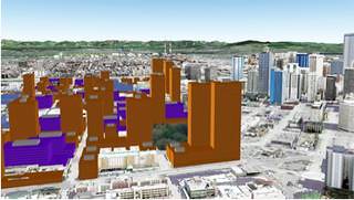
If you missed the SLU Community Council Newsletter article on the EIS, attached is a simulated view of what SLU and Capitol Hill would look like from the Space Needle after a full buildout (20-30 years out).
A rule of thumb here: if you can see it from the Space Needle, you can see the Space Needle from it. From that it looks like Alternative 1 would impact views from Pike/Pine and the Mirabella but none of the other Alternatives would. The rest of Capitol Hill is clearly visible from every Alternative. The view studies do not show the step back requirements that are in the SLU Urban Design Framework (since it hasn’t been adopted yet). So, for example, Thomas St should still maintain views of the Space Needle. (The step backs would be like the Amazon building shown on the right in the Thomas view simulations in Appendix D.)
Also as ChrisG pointed out in the comments, the Seattle Transit Blog had a lively discussion this week South Lake Union: How High Should We Go?