


What will the future of bicycling on Capitol Hill look like? The city is developing an update to the Bicycle Master Plan adopted in 2007, and you will have your first chance to get a look at the draft network map of future bicycle facilities they have created.
The first meeting is Wednesday, 5:30–7:30 PM at City Hall. There’s another meeting Thursday down south — hey, you could ride your bike.
Before the proposed network map is released, here’s a look at how the Hill’s bicycle network has changed since the 2007 plan was adopted. SDOT released a document showing the state of bicycle facilities since the 2007 plan (I posted more about that report at Seattle Bike Blog). Here’s what existed in 2007:
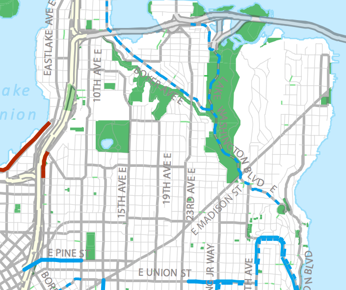
Here’s what exists today:
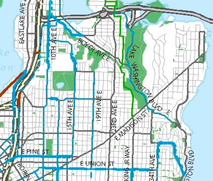
And here’s a look at potential opportunities for facilities (green lines):
 More details on the meetings from SDOT:
The City has been developing a vision of making riding a bicycle a comfortable and integral part of daily life in Seattle for people of all ages and abilities. The Seattle Department of Transportation (SDOT), the Seattle Bicycle Advisory Board (SBAB), community members and local businesses have been hard at work over the past several months revising a citywide bicycle network map, and developing possible encouragement and marketing programs to achieve this vision. Three public meetings and an online Lunch and Learn are being held to get feedback at this critical juncture in the planning phase.
What: Public Meetings
Time: 5:30 to 7:30 p.m.
Date and Location:
November 7 – Seattle City Hall, Bertha Knight Landes Room, 600 Fourth Avenue
November 8 – New Holly Gathering Hall, 7054 32nd Ave South
November 13 – UW Gould Hall, NE 40th Street between University Way NE and 15th Avenue NE
Purpose:
SDOT is sharing a draft citywide map of proposed bike facilities so that the public can provide feedback about riding bikes on the identified streets and if there are gaps. Different types of facilities such as Neighborhood Greenways and cycle tracks will be discussed, and staff will be on hand to discuss the overall policy direction of the plan update, trade-offs of adding bike improvements and the effectiveness of possible programs to encourage more bike riding.
People unable to attend a public meeting are invited to participate in an online Lunch and Learn on November 15 from 12 to 1 p.m. Individuals can register at https://www3.gotomeeting.com/register/718370686. SDOT staff will provide an overview of material displayed the public meetings and the audience will be invited to submit questions. Space is limited.
All of the work completed to date is available online at www.seattle.gov/transportation/bikemaster.htm. Click on the Project Library to read all the presentations given to the SBAB, the State of the Seattle Bicycling Environment Report and the Phase One Public Engagement Summary Report.
12th Ave investments, please to accompany the lovely Broadway bikeway. What route does the green line running perpendicular from 12th down the hill represent? I want that one too
Better/more bike routes from Capitol Hill to the U district would help me.
And I want safer options for riding into and out of downtown. The current route up and down Pine terrifies me because of all the cars that swoop across the bike lane without even checking for bikers. I think the drivers along that street tend to be in a hurry and/or unfamiliar with the area.
If you mean the one running west it looks to be on Mercer, which will dead-end at Melrose. Which would be great when/if the “Melrose Promenade” ever gets built, but in the mean time will be good for getting to Top Pot / Sun Liquor / Summit Pub (of course it also connects to the path that leads to the Lakeview overpass which is already a “sharrows” but a particularly narrow and steep one) . If you mean the one east to 23rd, that would be on Republican.
Seattle continues to increase connectivity between neighborhoods, and it’s awesome. Capitol Hill is already one of the best, but I love the winding path from the conservatory towards UW. The addition of bike lanes from First Hill to ~32nd Avenue on Madison is also crucial, though many cyclists already ride on the unsigned street anyway.
Great news! Keep it up
The route down 19th through interlaken park and underneath the montlake bridge works great for me getting to the UW. Little traffic, lots of trees. How do you get there currently? It’s a much nicer ride than up pine st for sure.