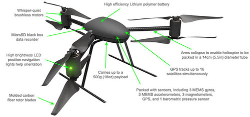
When the mayor held a town hall meeting at the Central District’s Kawabe House earlier this month, one resident voiced concern about the police department’s new drones, also known as unmanned aerial vehicles. Mayor McGinn said he sees the drones, which can only sustain a few minutes of flight at a time, as “a low-cost alternative to having a helicopter” at a scene.
While SPD wants to sell the drone, a Draganflyer X6, as a glorified RC helicopter with a camera attached that could be useful to get overhead shots during incidents, others see the beginnings of a dystopian surveillance society with few rights to privacy.
You can check out the drones for yourself tonight (Thursday) at Garfield Community Center. SPD will display one of the units and hold a Q&A about them starting at 6 p.m.
From SPD:
The Seattle Police Department is one of 50 organizations that have received permission from the federal government to operate unmanned aerial vehicles (UAV) – also known as ”drones”.
What – UAV Question & Answer
When – October 25, 2012
Time – 6:00 p.m.
Location- The Garfield Community Center, 2323 East Cherry Street, Seattle, WA 98122
Seattle Police Arson/Bomb Squad Lieutenant Greg Sackman will be on hand with the UAV to answer your questions and receive your feedback about our proposed policy.
A draft copy of the Department’s operational protocol is attached below:
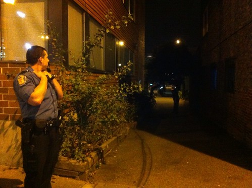
A man was hit by an apparent bullet ricochet in the alley on the southeast corner of 12th and Jefferson around 8:15 p.m. Friday. According to officers on the scene, the victim was not seriously injured (got grazed, it sounded like). The Gang Unit was en route to investigate while CDNews was on scene.
Officers were working the scene, marking shell casings and taking photos.
Seattle University security sent the following campus-wide alert:
At approximately 8:17 pm this evening, September 21st, Seattle University Department of Public Safety was made aware the Seattle Police Department was responding to shots fired in the area between 12th and 14th Ave along E. Jefferson St. A non-affiliate male was struck by an apparent ricochet and was transported to an area hospital. Seattle Police Department gang units are currently investigating the shooting. The police have opened the area to travel, however you are encouraged to avoid this area as they continue their investigation. No suspect information is currently available.
This incident is being investigated by the Seattle Police Department. If you have any additional information regarding this criminal incident please call Seattle Police at 911 or the DPS office at 206-296-5990.
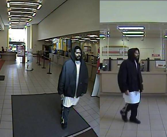
Police are searching for a man they say stabbed a security guard twice in the abdomen before fleeing the Madison and Minor Bank of America branch shortly before 10:45 a.m. Tuesday. UPDATE: At 4p, SPD announced the suspect had been arrested in Federal Way. More details to come.
Police have released images of the suspect, captured on bank security cameras. Anyone with information about him should call 911, police say.
From SPD:
A man armed with a knife stabbed a Bank of America security guard without warning at 10:41 this morning. The suspect walked into the Bank of America at 1201 Madison Street and inquired about opening an account. The suspect told the teller that he would return later to complete the paperwork. The man walked out of the bank and stabbed the victim/Security Guard twice in the abdomen.
The suspect then fled eastbound on Madison Street. Seattle Fire responded and transported the victim to an area hospital. He sustained two non-life-threatening stab wounds to his abdomen.
The suspect is described as a black male, late 20′s to early 30′s, 5’6 tall, 180 pounds with a scruffy beard. He is wearing a black puffy jacket with a long white T-shirt underneath and dark colored pants with a light colored stripe running down the sides. Anyone with information about this man is asked to call 911. Do not contact the suspect, he is clearly dangerous and may be armed with a knife.
Despite a Senate bill that would prevent such an action, the United State Post Office may be forced to close its Broadway location and consolidate operations at its 4th and Lander facility because of new legislation making its way through Congress, officials say. The possible cutback is one of the hurdles clouding the negotiations for a new lease for the Broadway facility that CHS reported on in March.
“We’ve pretty much agree to wait and see what the House of Representatives does” before making the decision, Seattle USPS spokesperson Ernie Swanson said. The Senate has already passed a bill that would prevent such consolidations, but the bill the House is currently considering is very different from the Senate version.
If the consolidations happen, USPS hopes to keep a retail presence in the areas that lose facilities. Though the letter carriers and the vehicle fleet at 23rd and Union would move, residents could still be able to meet their mail needs either in the current space or a nearby spot, said Swanson.
“If that hapens, we would make every effort to find a suitable alternate location or just keep the retail where they are if that looks like the better option,” said Swanson.
USPS has significantly reduced its workforce in recent years, hiring very rarely and letting people retire or leave voluntarily. Swanson said they hope to avoid further layoffs if the consolidation occurs, but nothing is certain.
Last July there was a list of some 3,700 post offices that would close or consolidate. The Broadway branch was not on the list and has not yet been added, according to officials. As USPS waits to work out a new the lease, the House legislation could enable such a cut
Mark Rozgay, manager of the trust that owns the land at Broadway and Denny where the post office is located, told CHS us he is in the process of negotiating a new 10-year lease with USPS. In March, postal officials said there were no “concrete plans” to shutter the Broadway office or consolidate it at another location.
“For many years we’ve been trying to find another location,” Swanson said. “It’s small, old, there’s no customer parking, no employee parking, and we have to rent space offsite to park the trucks. We just haven’t been able to find a replacement. It’s tough to find space in the Broadway area. That’s not to say something might not change, but there are no plans to close or consolidate.”
Plans for upgrading the Broadway post office building have been in the air for years — here’s our report on the situation from May 2009. The current lease runs out later this year CHS has learned the lease is through 2015.
SPD is looking for information about a Friday night armed robbery at Summit and E Olive St. Two women were robbed at gunpoint by one man, police say, and the suspect got away with their purses.
From SPD:
On May 4th at approximately 10:53 p.m. two female victims were walking on Summit Avenue near East Olive Street when they were approached by a lone male suspect. The suspect displayed a small black revolver and stole both victims’ purses. The suspect then fled westbound on East Olive Street. Neither victim was injured during the robbery.
Responding officers conducted an area search however, the suspect remains at large.
The suspect is described as a Hispanic male, 5’6″ to 5’8″ tall and wearing a black hat, black coat, and black pants.
Anyone with information about this incident or who may know the identity or whereabouts of the suspect is asked to call 911 or Seattle Police and refer to this incident. Anonymous tips are welcome.
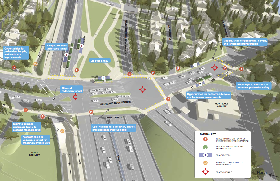
We’ve already looked at the state’s concepts for a walking and biking trail across Lake Washington via a reconstructed 520 floating bridge. But the reconstructed bridge will also come with redesigns for the entire section of highway between the lake and I-5.
Earlier this month, the state held an open house in Montlake to take a closer look at designs for that neighborhood. Future open houses will focus on the Portage Bay (May) and Roanoke Lid (June) sections.
The proposed design includes a lid through Montlake with new park space and changes to both Montlake and Lake Washington Boulevards. The bus stops and transit lanes would be on the lid as well.
People will be able to access the new biking and walking trail from existing streets and sidewalks as well as a new trail that loop under the bridge near the lake shore and head toward the Arboretum.
There, the trail could meet up with a new proposed multi-use trail through the arboretum, which would provide a safe alternative to Lake Washington Boulevard for people on foot and bike. Lake Washington Boulevard will likely remain a busy roadway. For more on the arboretum trail, see my coverage at Seattle Bike Blog.
The next meeting will be May 19 (details TBA) to discuss the Portage Bay section of the design. As we noted previously, plans for this section of the project do not yet include a biking and walking trail to connect to Roanoke Park and Capitol Hill, though that option is being sought by biking and walking advocates.
For more details on the Montlake plans, see the state’s boards presented at the April open house.
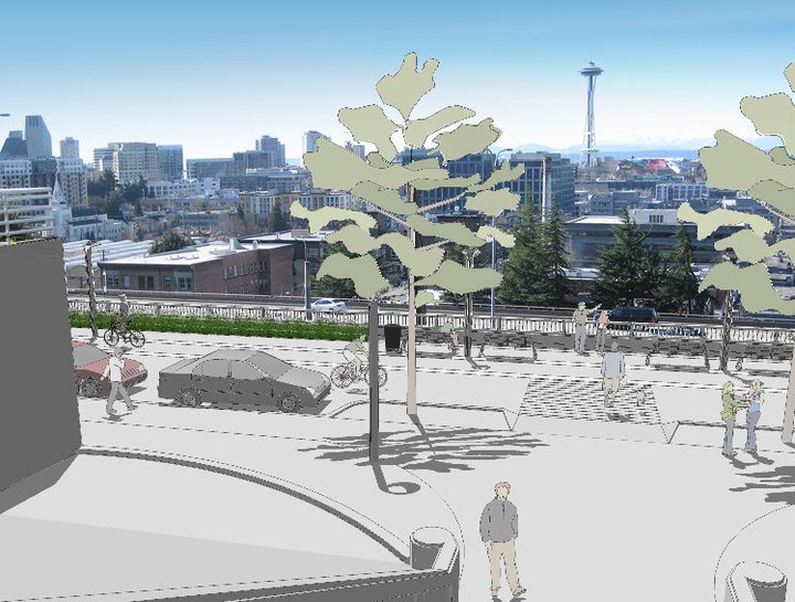
A new floating bridge across Lake Washington has the potential for solving another pressing transportation problem for the region — the steep, biker and pedestrian-intimidating slope up Capitol Hill.
As we reported last week, the state is moving ahead with design work on a new SR 520 floating bridge even though Olympia needs to come up with another $2.22 billion to pay for the $4.65 billion project. One big change with the new bridge (other than it being built so that it won’t fall down in an earthquake) is the addition of a trail for walking and biking across Lake Washington from Montlake to Medina.
However, the plans so far have not included an extension the trail through to northern Capitol Hill, where it could connect with popular bike routes to the University Bridge, Broadway, Interlaken Park and downtown. One of the poster boards for a late March open house described the section of 520 between Montlake and I-5 as a “parkway,” but the map does not include a walking and biking path.
Writing over at Seattle Bike Blog, I argued that building this connection would be a tremendous opportunity to not only actualize the new Lake Washington trail, but also to connect Montlake, Eastlake and north Capitol Hill. The hills from Montlake to Capitol Hill (and downtown) are among the steepest in the city, which is a significant barrier to people walking and biking between the neighborhoods. For the 520 Bridge to serve as an effective bicycle commuter facility from the Eastside to downtown Seattle — our region’s largest employment center — this connection is vital. For Capitol Hill, it would be a big neighborhood asset.
The state is holding a public meeting April 12, and biking and walking access is on the program for discussion. Details:
We’re continuing the SCDP process in April by hosting the first of four interactive public sessions to explore design refinements that support Puget Sound mobility and livable Seattle neighborhoods.
Join us for the first public session on April 12 when we will focus on:
Shelby/Hamlin neighborhood and the canal reserve area
East Montlake Park and the planned SR 520 stormwater facility
Montlake shoreline under the planned SR 520
East Lake Washington Boulevard
Bicycle/pedestrian connections to regional and local activity centers
Event details:
Time: Thursday, April 12, 4:30-7:30 p.m. Short presentation at 5 and 6 p.m.
Place: Museum of History & Industry (MOHAI) 2700 24th Ave. East Seattle, WA 98112 Located just north of SR 520 in Montlake.
Even though young people today are driving far less than previous generations, there are still a lot of teens getting behind the wheel. And a lot of them go out and break traffic laws.
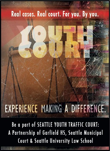
If you are one of those teens who has received a traffic ticket, you might find yourself in a different kind of courtroom starting this month. Garfield High students will staff a new Youth Traffic Court at the Seattle University School of Law, the first of its kind in Seattle.
Students will be the jury, judge, defense and prosecution for the cases, and they have the ability to impose penalties such as community service, youth court jury duty or education programming. If the ticketed youth takes responsibility and carries out the prescribed penalty, the infraction will not appear on their driving record.
From the city’s press release:
Teen drivers who admit they committed their traffic offense will have the opportunity to have their punishment set by their peers instead of a judge through a new Youth Traffic Court alliance among Seattle Municipal Court, Seattle University School of Law, and Garfield High School. The city’s first Youth Traffic Court will allow eligible teen drivers to appear before Garfield High School students at Seattle University School of Law, rather than in Municipal Court. The first cases are scheduled to be heard in March.
“Youth courts provide an opportunity for teens to take responsibility for their driving mistakes, while keeping their driving record clean,” said Margaret Fisher, a Distinguished Practitioner in Residence at Seattle University School of Law and a national expert in youth courts, who is overseeing the law school’s involvement.
Qualified defendants will appear before the Youth Court, receive a sanction of community service, youth court jury service, preventative education and/or similar consequences. If they comply, the infraction will be dismissed and it will not be reported to the Department of Licensing or appear on the defendants’ driving record.
Garfield High School students will serve as judges, jurors, prosecutors and defense attorneys and court staff. They will be trained and supported by volunteer law students from Seattle University School of Law. The high school students will take part in an intensive training before the first hearing and will meet with their law school mentors regularly.
“Youth court provides a meaningful civic opportunity for students, who will have the responsibility of deciding real cases,” said Judge Karen Donohue.
The Seattle Police Department, Seattle City Attorney’s Office, Seattle Municipal Court, and Seattle University Law School faculty are all committed to working with students through this innovative program.
Organizing and implementing the Seattle Youth Traffic Court has been a collaborative effort involving Fisher, Seattle Municipal Court Judge Karen Donohue; Seattle Municipal Court Magistrate Lisa Leone; Sally Haber, director of the Children’s Literacy Project at Seattle University; Diana Singleton, Director of Access to Justice Institute at Seattle University School of Law; and, Corey Martin, history teacher and SYTC advisor at Garfield High School. Seattle Youth Traffic Court was made possible, in part, by a grant from the Seattle City Council.
If you would like more information, please contact Professor Margaret Fisher at [email protected].
The city plans to build 11 miles of family-friend walking and biking routes every year, and Central Seattle Greenways (CSG) wants to make sure the central neighborhoods are not left behind.
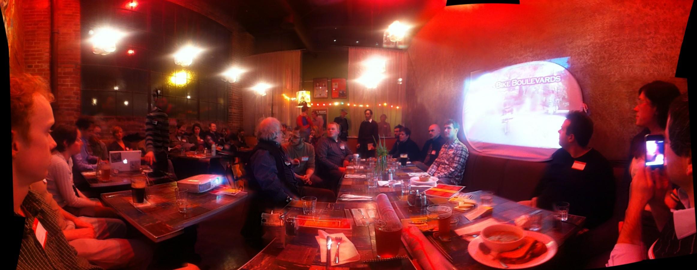
About 40 people squished into Central Cinema February 9 for the first CSG meeting. Residents from Capitol Hill and the greater Central District neighborhoods put their heads together to come up with some potential family-friendly walking and biking route ideas and discussed ways to promote them.
Neighborhood greenways are basically low-traffic neighborhood streets that are designed to prioritize walking and biking as a way to connect homes and important neighborhood destinations. They include traffic calming to slow motor vehicle traffic and safe crossings at busy streets so that walking and biking is easy, safe and efficient.
The Seattle Times created an interactive map showing bicycle-involved collisions between 2007 and 2011. Though bicycling has increased significantly since 2007, the number of collisions has stayed constant. This could mean that the more people bicycling, the safer it becomes. Perhaps not surprising, the map shows that the Capitol Hill streets with the most collisions are Pike, Pine, Broadway and 12th Ave.
360 image of February 6 meeting by Adam Parast
Central Seattle Greenways (which, full disclosure, I am part of) has the goal of providing routes for walking and biking that are further away from heavy car traffic. The group is now working to apply for a small Neighborhood Matching Fund grant, which can provide up to $20,000 to selected projects. Grant applications are due March 12, so a lot of work needs to get done before then.
To keep updated on those meetings and participate in other planning discussions, you can join the Google Group email list. Central Seattle Greenways also has a website, Facebook and Twitter.
From the Melrose Promenade Facebook page
The group is not starting completely from scratch on Capitol Hill. Mike Kent of the Capitol Hill Community Council presented planning work already under way for Melrose Ave. The Melrose Promenade would redesign the road, particularly north of Denny, so that it is more comfortable for walking and enjoying the excellent views. CSG embraced the plans, and general consensus was that the group should do whatever it can to move the plan forward.
To get an idea of what routes might work as neighborhood greenways, people split into three groups. Each group had a big map on the table, and people highlighted important neighborhood destinations — such as schools, big transit stops (present and future), parks, churches and commercial centers. They then drew on the maps to highlight neighborhood streets that could connect these destinations (see below).
Several Capitol Hill route needs became clear. There are several good options for an east-west route somewhere between Madison and Volunteer Park and good options for a long north-south route connecting Volunteer and Judkins Parks. All groups agreed that all of Federal Ave would be a good option, though it needs to be repaved (which could be costly).
In the CD, there was strong support for a route on Columbia Street connecting the First Hill Streetcar stop at Swedish First Hill to Madrona — stopping by Seattle U, Swedish Cherry Hill, Garfield and the Cherry Street commercial areas along the way. People also supported routes parallel to 34th Ave in Madrona and routes to help connect Montlake with the Hill and Madison Valley, to name a few.
The next step is to decide the best grant ideas. $20,000 is not really enough money to build a route (which cost somewhere in the neighborhood of $150,000/mile). However, it could be enough for design planning (a requirement for the Melrose Green Street project, for example).
Or it could be an opportunity to bring more people in the community together. One idea discussed would be a big cross-neighborhood street party, where a loop of neighborhood streets is turned into a big park for a few hours one weekend day. Organizations and individuals can host parties, music, exercise classes, food, etc along the way. Car traffic is limited, and police or volunteers are on hand to help people cross busy streets. Similar ciclovia-style events have been increasingly popular around the world (and, in fact, the idea has origins right here in Seattle with Lake Washington’s Bicycle Sundays).
The next two meetings will be about grant planning (6:30 p.m. February 27, location TBA) and a route-scouting neighborhood bike ride (2 p.m. March 4, meet at the Judkins Park Tennis Courts).
Finding a safe place to cross busy streets and dodging speeding cars are two of the biggest impediments to increased walking and biking, and groups from all over Seattle think they have the solution.
From North Delridge to Beacon Hill to Wallingford, citizen groups pushing neighborhood greenways — basically corridors of low-traffic residential streets with added traffic calming, greenery and safe crossings at busy streets — have been making the case to SDOT that fast, family-friendly walking and biking routes would be a cost-effective way to make their neighborhoods safer, healthier and more connected to their neighborhood destinations (schools, parks, commercial centers, etc).
Now (with the help of yours truly), a group is forming to promote neighborhood greenways in the CD and Capitol Hill. The first community meeting is 6:30 p.m. February 9 at Central Cinema. Presenters will explain how neighborhood greenways work, and the group will discuss ways to promote them to the city and to others in the neighborhood.
From Central Seattle Greenways:
Neighborhoods throughout Seattle are realizing their dreams for family-friendly walking and biking routes using Neighborhood Greenways – safe, low-cost and low-stress walking and biking corridors connecting people with the places they want to go. By adding traffic calming, safe crossings at busy streets, and extra trees and greenery, a network of low-traffic streets can be transformed into useful, park-like routes around the neighborhood.
In 2012, the Seattle Department of Transportation will fund or build Greenways in Wallingford, Beacon Hill, Ballard, North Delridge and Greenwood, with plans to continue funding community-driven Greenways through 2013. Let’s make sure Central Seattle – Central District, First Hill, Capitol Hill, Madrona, and Leschi – doesn’t get left behind!
Neighborhoods that have been successful at bringing Greenways to their streets relied on engaged citizens to build community consensus around routes and advocate for them during planning and funding processes. Following this recipe for success, we invite you to participate in Central Seattle Greenways, a community group dedicated to bringing Neighborhood Greenways to Central Seattle.
Join us for our kickoff community meeting at Central Cinema (21st & Union) on Thursday, February 9th, 6:30-8:30 pm, as we start building momentum for safe, direct, and low-stress walking and biking routes that serve Central Seattle’s residents, families, businesses and neighborhood organizations.