


A group led by Capitol Hill Housing is championing a 12th Ave route for the streetcar project that is planned to connect the Capitol Hill light rail station to the First Hill area and, eventually, Union Station in the International District. CHS covered a Seattle City Council briefing last week detailing the progress on planning for the route.
Meanwhile, Seattle City Councilmember Tom Rasmussen has clarified his objections to the planned streetcar route. Council transportation committee chair Jan Drago put out a call for community support for the streetcar after Rasmussen’s statements at last week’s Council streetcar briefing. Rasmussen told CHS he does not plan to take any actions to stop the streetcar despite his questions at last week’s briefing about how the project’s money was going to be spent. But that doesn’t mean he doesn’t think the project is a good use of money — even if Sound Transit is footing the bill. “The problem I have with building a streetcar netwok in Seattle is that it is so wildly expensive compared to more bus service,” Rasmussen said. “Why should we go through incredibly expensive effort to build a new transportation system? We’d get so much more from added routes on Metro.”
Sound Transit’s position on the matter is that the streetcar route — and lots of other, um, stuff — was part of the ballot measure approved by voters in 2008. So planning for the streetcar continues.
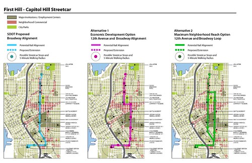
The 12th Ave group has released two maps to offer alternative concepts to the city’s plan to path the streetcar route directly down Broadway.
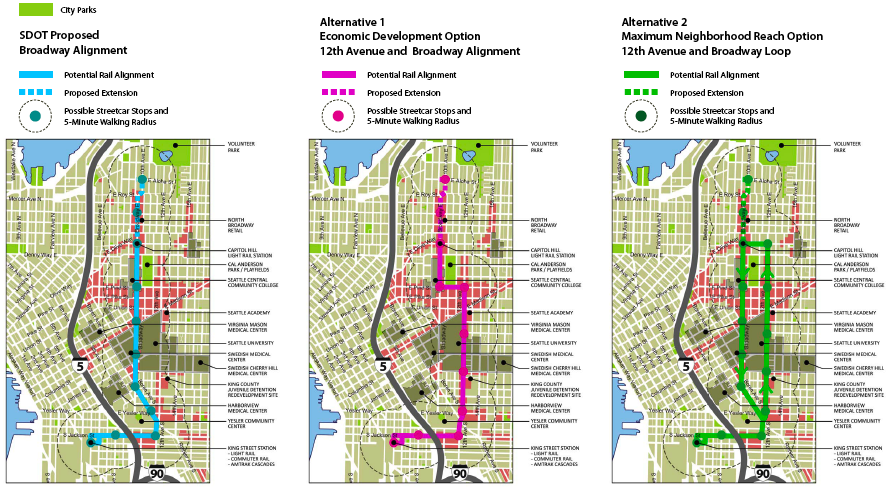
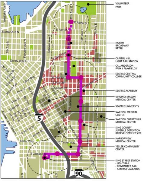
Alternative 1 shows a route that utilizes 12th Ave between Jackson and Pine before making a jog down Pine and connecting with Broadway and on to the light rail station between Denny and John.
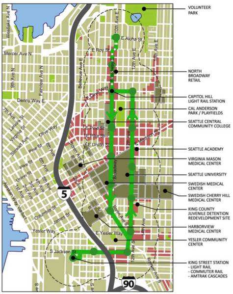
Alternative 2 illustrates a more audacious plan that would create a loop utilizing both Broadway and 12th Ave in an effort to put more riders withing walking distance of the line and potentially reduce the impact to traffic and parking on Broadway than the city’s plan.
Capitol Hill Housing has a few significant projects planned along 12th Ave including this effort to create a mixed-use development at the site of the East Precinct parking lot near 12th and Pine. You can learn more about those and other issues surrounding the 12th Ave core at Capitol Hill Housing’s annual forum, The Future of 12th Ave, next Wednesday, Aprill 22nd.
Central District Reports that the city is planning to hold meetings to gather community feedback on the plans before making a decision on the route in June.
Logging my vote for either 12th Ave route — business and pedestrian areas on and around 12th lend themselves to a streetcar even better than Broadway, and growth opportunity along 12th seems to be better than Broadway. Would also help to spread the crowd and transit options out from Broadway.
Like the loop, but density (building heights) would need to be increased on 12th to support the proximity to the rail.
much if not all of 12th is already zoned NC3-65, the highest zone for neighborhood commercial available. and Seattle University has the ability to go much higher than this already – up to 100 feet in some places, because of their special institutional zoning overlay. the primary issue on 12th is that hardly any places are actually built to this zoning envelope. so much land is literally vacant or used as parking lots (KC detention center, east precinct lot, etc) while Broadway, at least north of Jefferson, is completely built out by the hospitals and medical office.
Westlake was a disaster. It still is a disaster. The city is facing a class action lawsuit from quite a few cyclists who have been injured on those tracks.
Can we do a bicycle tour of the alternate routes with someone who knows about streetcars and knows the streetcar design proposals? Maybe by spending a couple hours up front we can avoid a few million dollars of mistakes.
I like the couplet idea. It saves space on both streets for bike lanes and parking and it expands the area served by the line.
I don’t know if I’m a fan of the couplet because the two directions are pretty far apart. It seems like it will get confusing knowing that you can only go one direction near you and seems like it might limit the usage. From a comprehension standpoint I think running it down just 12th is a much better idea, with a center platform station.
FYI: CHH also has a project in the works at the corner of 12th and Jefferson. More on that soon…
would be my suggestion.
That is my fear also. I agree that 12th would be a great street for it, but I’m worried that it will be a hard sell because it doesn’t serve First Hill very well. The couplet might end up being a compromise. What about going north on Boren to Cherry and then heading east across the SU campus to 12th? The line could then continue north on 12th to Pine or John before heading over to Broadway. I wonder where the streetcar shed will be? Hopefully they can integrate it into a new mixed-use building like they had originally planned for Pioneer Square. That’s my 2 cents.
Expensive, inflexable. and a major hazard to cyclists. whats wrong with buses? they can go all the same places and we can change the route as needed. Oh Yea, that might make some sence Jeez….
The illustration for the third option (“alternative 2”) is rather misleading. There should be two separate five-minute-walk-zones where the route is split between Broadway and 12th, but they are instead melded into one, giving the appearance of a larger service area. Someone on 15th or 16th. might be within five minutes of the eastern side of the loop, but that number is of little significance if he wants to take the streetcar southbound to First Hill without having to ride all the way up to the north end of the loop first, because he’ll still have to walk more than five minutes to reach the southbound route.
Also, are there any proposals for how to deal with the proposed extension under the loop scenario?
Keep in mind that service to and from First Hill is the primary reason for this streetcar. Sound Transit pulled several bait-and-switch moves after gaining large support in the neighborhood, including elimination of the First Hill station that was planned back when we were all sold on the rail system. This streetcar is an attempt to mitigate the effect of that elimination.
I mis-read the map.
wrote: “15th or 16th”
meant: “16th or 17th”
I know we can all disagree about what counts as First hill and what counts as Cap hill (I find Piecora’s and Seattle U, as south-of-madison places, get oddly lumped with first hill,- and 15th and 19th get forgotten completely).
However, if the goal is follow the letter of the law — connect first hill to cap hill/ the light rail system as if the light rail had actually gone there — then none of the three maps are doing the best job. Straight lines are cute on paper, but if you look at demo and zoning, a zigzag might be best!
Q: where was the proposed light rail station going to be, before it was yanked?
Idea: given the mission ‘connect first hill to cap hill via a transit system that doesn’t currently exist’, my dream route, picking up from Union station, would be:
Jackson to 12th to Boren (just as SDOT and alt2 show)
Continue on Boren all the way until Madison**
Follow Madison up and down various grades to 15th. Yeah, I said 15th.
Follow 15th to John (oh look, another hospital connection! This one with a birthing center!!)
Stop near, not at*, John & Broadway to link peds to light rail.
[You wanna loop? Make it here: extend from John & Broadway stop down olive way,
Head up bellevue to roy or mercer,
then Come back on Broadway to john, giving all the apartments on I-5 shores / northish cap hill a link to light rail.]
*Walking’s good for you, and good for retail: let’s not be so foolish at to miss an opportunity for boosting business by putting the streetcar stop ONTOP of the train stop. Put it at Harrison/Broadway, or Olive/Belmont for stimulus-package power.
** Long run on Boren->Madison Advantages: Still connects SU, does a better job of connecting hospitals (incl. VirginiaMason & HARBORVIEW)& retail (Madison between 6th and 17th), museum, public housing, and schools (incl NW school, O’Dea) – best of all: this gives First Hill *residents* a place to get on, rather than merely give SU students a short walk to get off: after all, who is more mobile for that potential walk / bus connection? 19 year old jesuits or pill hill seniors??)