It’s been a month of snow and ice on Capitol Hill. Here are 50 (and a couple more) of our favorite pictures and videos from the run of CHS “Snowbruary 2019” coverage. Thanks for sharing your wintry scenes with CHS. We’ve included many images from the crowd in the mix along with some of our favorite shots and clips from CHS. Something we missed? Let us know in comments. Continue reading →
Banks of dirty, wet snow line the edges of Capitol HIll’s streets while sidewalks remain a slushy mess. Cars probably won’t be spinning out once they make it to the street but the new spectator sport is watching people try to dig their cars out. Maybe lend a hand. Here are some wrap-up notes on Snowbruary 2019’s Wednesday.
Snow routes: Metro will restore most of its service and buses will operate on snow routes Wednesday morning “on a route-by-route basis,” the county says: Riders are encouraged to visit Metro’s MetroWinter.com website for route specific information on Wednesday morning before traveling and sign up for alerts. Online updates are underway for over 200 bus routes and will be available by Wednesday morning.
🚨❄️🚌❄️🚨 RIDER ALERT! Prepare for snow reroutes & delays Wednesday, and BEFORE you ride check if your ROUTE is operating and WHERE https://t.co/QujzOTMXRZ Then see if your TRIP is operating through Next Departures on our Trip Planner or text your stop ID to 62550. pic.twitter.com/mhKpk1gbew
No school: If the parents, grandparents, guardians, and child care pros in your life seem a little rundown, consider that Wednesday is yet another snow day. While the main streets are mostly clear, the soppy conditions moved Seattle Public Schools to declare yet another snow day: Schools will be closed on Wednesday, Feb. 13 due to adverse weather conditions. We thank the City of Seattle for their continued and diligent efforts to clear roads including many near our schools. Yet, many sidewalks and walkways are not cleared of ice and slush, and side streets in the north and south ends of the district continue to be icy. All activities, athletics and public meetings are canceled. There will be no preschool or Head Start.
As for make-up days, the district reminds there are two scheduled — June 21 and 24 — but says the state won’t consider any waiver requests “until after the threat of further weather closures has passed.” UPDATE: Seattle Mayor Jenny Durkan said Wednesday the city has been working with Seattle Public School and King County Metro “to discuss immediate next steps to try and get our children back into schools as quickly as possible.” Seattle Schools has workers out clearing sidewalks near its campuses and SDOT road crews are out again pre-treating roads in anticipation of another freeze Wednesday night. As for garbage, crews are out for Monday/Tuesday customers Wednesday with other customers on a one-day delay.
Levies: The district is declaring victory in Tuesday’s vote on two school levies. “These two levy replacements will help fund critical day-to-day operations for Seattle Public Schools, including salaries, textbooks and materials, as well as the rebuild of eight aging schools, improved safety and security, increased technology access, and added capacity across our district,” a statement on the successful votes reads.
UPDATE 8:45 PM: Sorry, parents. No school again Wednesday.
Original report: The rains came but so did more snow as a month of ice and cold on Capitol Hill has continued into its second Tuesday.
The expected warmer air did arrive and brought an overnight of sleet following a bout of even more wet, heavy snow that pushed Seattle much closer to the bring of the feared “snowmageddon.” Around 20,000 were without power at points of the night with reports of trees and branches giving way to the heavy snow. Large trees were reported down throughout the Arboretum and blocking streets including 19th Ave E. A car was smashed by one fallen tree near Interlaken Park. Seattle City Light reported one of the biggest problems is actually the melting snow — large branches relieved of the melting snow suddenly spring up and strike utility wires. Continue reading →
This week of snow and ice has added to Capitol Hill’s natural layer of “Did I just see that?” From the weekend, here’s another crazy scene from E Thomas. Hope everyone is keeping an even keel. Continue reading →
UPDATE 6:10 PM: Sorry parents — school is canceled again on Tuesday. Meanwhile, the afternoon and evening snow has added up. Many streets are as slick as ever and there are reports of cracked branches and trees on wires around the Capitol Hill area.
UPDATE 3:57 PM: The National Weather Service says things are shaping up as planned and “temperatures will continue to very slowly rise.”
UPDATE 2:25 PM: As you may have noticed, it is snowing pretty good out there but reports are that warmer air is moving up from the south and changing the snow into rain. For now, we are adding another inch or so to our “historic” Snowbruary totals.
Original report: A week of snow and ice is ready to enter a new phase Monday after another blanket of snow covered Capitol Hill starting Sunday night. The forecast calls for more snow… and rain.
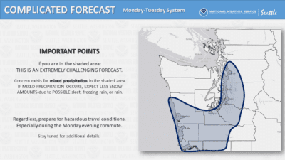
In what the National Weather Service is calling a “complicated” and “extremely challenging” forecast, Monday night is expected to bring a line of heavy snow north of Seattle and PROBABLY cold rain to the city and south:
Rain and snow, becoming all rain after 10pm. Low around 33. Wind chill values between 22 and 27. Southeast wind 13 to 21 mph, with gusts as high as 26 mph. Chance of precipitation is 100%. Little or no snow accumulation expected.
For Seattle and Capitol Hill, the forecast is a big change from earlier plans for a massive knockout punch of snow to hit the area in what is already the snowiest Seattle month in thirty years with more than 14 inches having fallen. CHS looked at the snowiest Capitol Hill days in recent years here. Continue reading →
UPDATE 2/10/19 5:45 PM: It’s here. Again. With snow falling again across Capitol Hill and beyond, Monday is shaping up as another Seattle snow day. Seattle Public Schools made the call earlier in the afternoon — its campuses will be closed Monday and most other schools in the area immediately followed suit.
The forecast looks increasingly serious for Monday’s storm:
Monday— Snow likely before 1pm, then rain and snow, possibly mixed with freezing rain and sleet. High near 36. Wind chill values between 21 and 31. North wind 5 to 8 mph. Chance of precipitation is 80%. Little or no ice accumulation expected. New snow and sleet accumulation of less than one inch possible.
Monday Night— Rain and snow, possibly mixed with freezing rain and sleet before 10pm, then rain between 10pm and 4am, then rain and snow likely after 4am. Low around 31. Wind chill values between 19 and 27. Northeast wind 6 to 13 mph becoming south in the evening. Chance of precipitation is 90%. New snow and sleet accumulation of 2 to 4 inches possible.
Tuesday— Rain and snow showers likely. Cloudy, with a high near 35. South southwest wind around 18 mph, with gusts as high as 24 mph. Chance of precipitation is 70%. New snow accumulation of less than one inch possible.
SDOT’s Sunday early evening road clearing work has focused on E Madison and E John with passes down 10th Ave E and 19th Ave E earlier in the afternoon. SDOT has posted more about how it handles snow and ice conditions here.
Original report: With overnight temperatures in the teens, Capitol Hill remained frozen Sunday as attention it shifting to another possible big round of snow on its way.
Forecasters say Sunday could bring a bit more snow but that Monday night into Tuesday could bring multiple inches on top of Seattle’s layer of snow and ice. The conditions could create quite a mess with Seattle in a border zone of snow and freeing rain: Continue reading →
As I write this, we’re getting ready for another round of snow, and while I don’t know how much will fall, I do know that it’s hard to be outside in cold weather. The warm-blooded wild creatures that live on the hill have to continue to find food, or at least not waste energy, despite the conditions. Unlike some species, which can shut their entire bodies down, even to the point of freezing solid, most birds and mammals need to maintain bodily functions through the coldest months. Birds don’t exactly have it easy, they can’t layer on fat with high metabolisms and the need to be light enough to fly, but they do have the benefit of being able to migrate away.
What do squirrels, raccoons, or even rats do in a cold spell? Continue reading →
UPDATE 2/9/19 7 AM: More than a half foot of snow fell on Capitol Hill overnight in a two stage snowstorm that at first seemed to be falling short of expectations.
But with snow steadily dumping, CHS found the Hill in full snow motion by 11 PM Friday with snowball fights and sledding everywhere you turned.
UPDATE 2/8/19 9:45 AM: The predictions are playing out. Seattle is set to be walloped by heavy snow with the biggest push coming sometime after 3 PM and lasting into the night. Forecasts for the Seattle area remain in the 6 inches and up zone with a cold and blustery weekend to follow. A winter storm warning has been issued through Saturday afternoon. Chances of snow continue through next week with highs topping out just above freezing.
Seattle Police say they are adding additional emergency services during the storm with dedicated transport vans to take people to shelters. Services will be available citywide through Wednesday. SPD says to call 911 if you believe someone is cold and in need. The Seattle Times is reporting that a 59-year-old died of exposure at the SoDo light rail station Thursday morning during the freezing temperatures.
Wanna good reason to leave work and start your weekend early? How about snow as an excuse! The heaviest snowfall is expected to reach the Seattle Metro after 3 PM this afternoon and continue through the evening rush. If you do have to be out…BE CAREFUL! #WAwxpic.twitter.com/jShTnE1Cx9
PREVIOUS UPDATES: The National Weather Service is predicting five to eight inches of snow starting Friday and another week of freezing temperatures across Seattle.
Heavy snow possible. Total snow accumulations of 5 to 8 inches possible. There remains some uncertainty in the details as a few areas could see a foot of snow while a few other locations may only see 2-4 inches. Windy conditions will develop late Friday night into Saturday with north winds 20 to 35 mph. Temperatures late Friday night through Saturday will fall through the 20s.
The forecast calls for the more serious snow in Seattle to begin falling Friday afternoon and some models show we could get more than a foot in the area. The storm will also be accompanied by heavy winds so get your flashlights ready. Continue reading →
Residents around Capitol Hill began another day of icy — but partially thawed — conditions Wednesday as Seattle awaited another inbound winter storm and promises — and threats — of more snow through the weekend.
The Hill’s side streets and many sidewalks remained an icy mess so it was best to take it slow. The city’s designated snow and ice routes — marked green and gold in the map below — were mostly clear sailing for busses, cars and bikes. Areas of shade on side streets and sidewalks were especially treacherous, however. Be safe, stay warm was the mantra for the day. Continue reading →