
UPDATE 6:10 PM: Sorry parents — school is canceled again on Tuesday. Meanwhile, the afternoon and evening snow has added up. Many streets are as slick as ever and there are reports of cracked branches and trees on wires around the Capitol Hill area.
UPDATE 3:57 PM: The National Weather Service says things are shaping up as planned and “temperatures will continue to very slowly rise.”
UPDATE 2:25 PM: As you may have noticed, it is snowing pretty good out there but reports are that warmer air is moving up from the south and changing the snow into rain. For now, we are adding another inch or so to our “historic” Snowbruary totals.
Original report: A week of snow and ice is ready to enter a new phase Monday after another blanket of snow covered Capitol Hill starting Sunday night. The forecast calls for more snow… and rain.
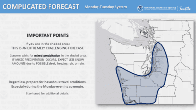 In what the National Weather Service is calling a “complicated” and “extremely challenging” forecast, Monday night is expected to bring a line of heavy snow north of Seattle and PROBABLY cold rain to the city and south:
Rain and snow, becoming all rain after 10pm. Low around 33. Wind chill values between 22 and 27. Southeast wind 13 to 21 mph, with gusts as high as 26 mph. Chance of precipitation is 100%. Little or no snow accumulation expected.
For Seattle and Capitol Hill, the forecast is a big change from earlier plans for a massive knockout punch of snow to hit the area in what is already the snowiest Seattle month in thirty years with more than 14 inches having fallen. CHS looked at the snowiest Capitol Hill days in recent years here. Continue reading →


